

The recent proposal to list the monarch butterfly as a threatened species has highlighted the need to understand where habitat is present and where it can be restored on the landscape. In 2024, using remote sensing technology, the Monarch Joint Venture (MJV) initiated a project to evaluate pollinator habitat on energy and transportation rights-of-way (ROW) across Minnesota. Funding for this project is provided by the Minnesota Environment and Natural Resources Trust Fund as recommended by the Legislative-Citizen Commission on Minnesota Resources (LCCMR). The project has three main objectives:
Conduct drone (UAV) surveys on Minnesota’s energy and transportation lands to quantify common milkweed (Asclepias syriaca) stems and estimate nectar resource availability (floral cover).
Collaborate with interested parties to prioritize an invasive species, which will be used to develop a new algorithm for invasive species detection.
Provide in-person and online training opportunities to enable others to independently apply this remote sensing technology.
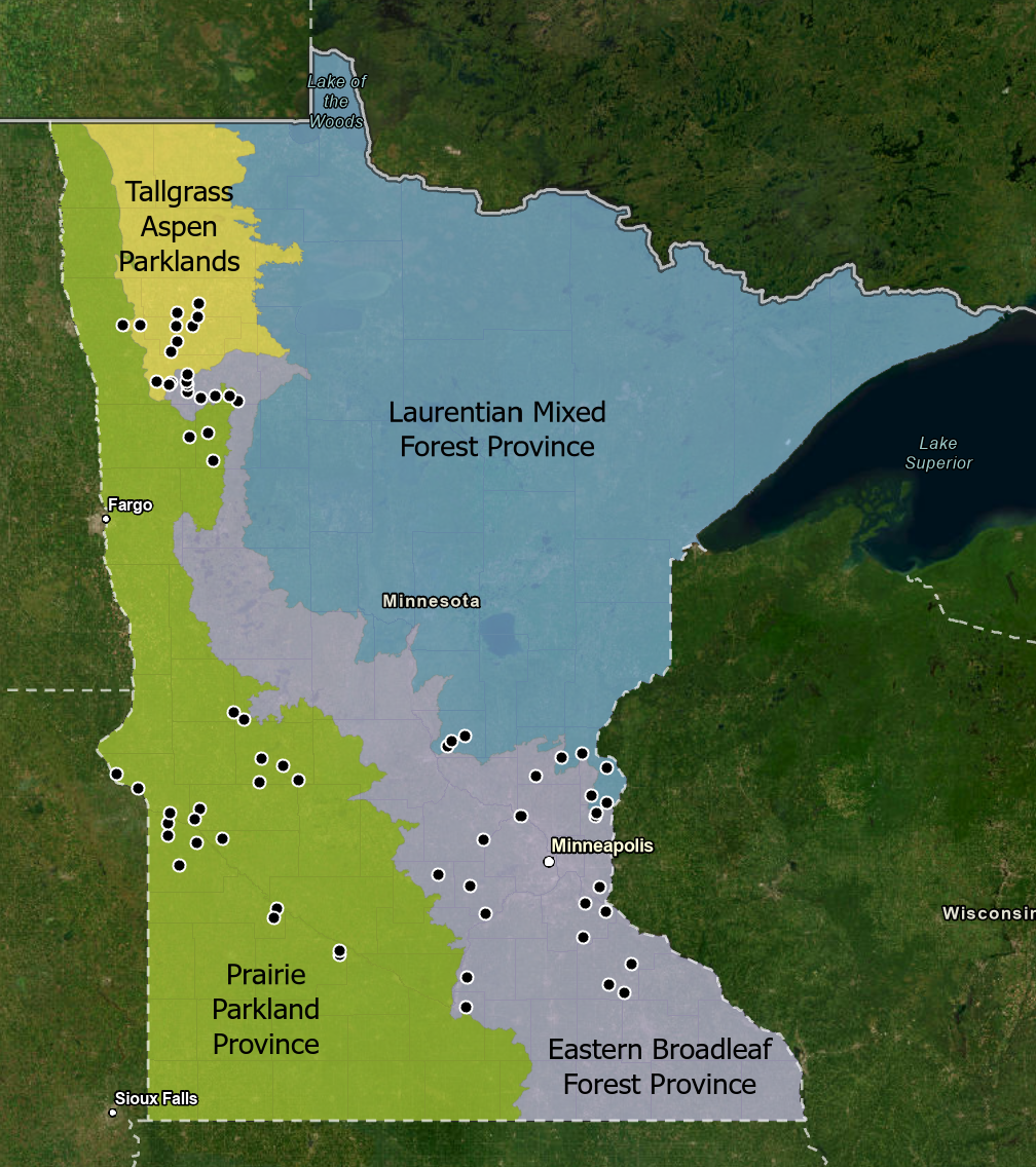
In 2024, the MJV field team surveyed 68 energy and transportation sites (Figure 1) using remote sensing technology. Sites included roadsides, solar arrays, and powerline rights-of-way managed by 6 collaborators. The surveys spanned all four of Minnesota’s main ecoregions (Laurentian Mixed Forest, Eastern Broadleaf Forest, Tallgrass Aspen Parkland, and Prairie Parkland). In total, the surveys detected over 6,000 milkweed stems, and milkweed densities ranged from 0 to 495 stems per acre. Although some sites provided minimal breeding habitat for monarchs, others far exceeded the estimated milkweed densities for Midwestern rights-of-way (see Thogmartin et al., 2017). At the end of the field season, we shared reports for each site with land managers and invited them to engage with the project in 2025.
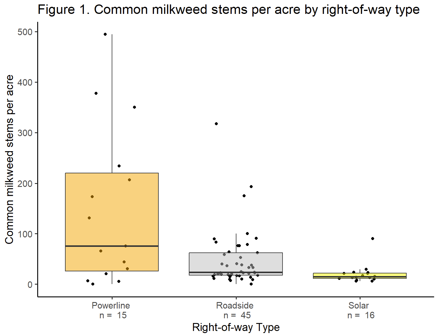
Through the remote sensing surveys, we explored how common milkweed (Asclepias syriaca) density varied across right-of-way types (Figure 2). The preliminary results suggest that powerline and roadside sites have higher milkweed density than solar sites. However, many powerlines were adjacent to roads, making it impossible to distinguish between them in this year’s data. In 2025, we hope to sample more powerline corridors isolated from roadsides to investigate differences in these site types.
We were also interested in comparing remote sensing to other habitat monitoring protocols to assess varying levels of survey effort. Therefore, at a subset of sites, we compared remote sensing to established habitat survey methods within the same site. On roadsides, we conducted the Integrated Monarch Monitoring Program (IMMP) and the Rights-of-Way as Habitat Working Group’s Pollinator Scorecard. IMMP is a robust in-field method to assess monarch breeding and migration habitat, and the Pollinator Scorecard is a consistent pollinator habitat evaluation method that is broadly used across right-of-way sectors. On solar sites, we compared remote sensing to IMMP and the Habitat Friendly Solar Site Assessment Form, a program managed by the Minnesota Board of Water and Solar Resources. A comparison of these survey methods will inform future monitoring efforts and identify applications or limitations of the data.
To begin progress on a new algorithm for invasive species detection, we polled land managers to identify the highest priority invasive species along rights-of-way in Minnesota. Some respondents emphasized widespread noxious weeds such as reed canary grass (Phalaris arundinacea) while others prioritized newly invasive species such as tree of heaven (Ailanthus altissima), which are critical to detect and eradicate before they spread. We compiled a ranked list of invasive species based on their responses. The top species were Canada thistle (Cirsium arvense), reed canary grass (Phalaris arundinacea), bird’s foot trefoil (Lotus corniculatus), and common buckthorn (Rhamnus cathartica). Based on the survey results, we are collaborating with partners to prioritize Canada thistle (Cirsium arvense) for the first invasive species model. The other recommended species will be considered for future models.
In 2025, we plan to further build the dataset by involving more collaborators and expanding to new geographies within Minnesota. See our list below for specific needs. To increase access to this remote sensing technology, we are developing online training resources in collaboration with POLLi, our technology partner, and we will provide additional in-person training for organizations interested in applying remote sensing on the habitats they manage.
We are seeking additional energy and transportation sites in Minnesota for summer 2025! If your organization is interested in participating, please fill out this form. To fill gaps in our dataset, we are especially interested in:
Sites in northeastern Minnesota
Powerlines that are not adjacent to roadsides
Recently planted solar sites
Solar sites that are more than 5 years old
Solar sites not enrolled in Habitat Friendly Solar
Railroad sites
Pipeline sites
Many thanks to our collaborators on this project in 2024! We look forward to sharing more results as the project develops.