
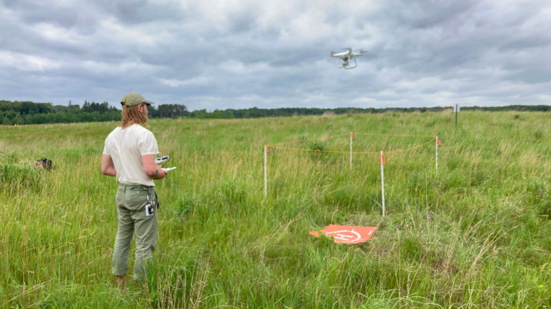
While we close out the 2024 remote sensing field season, we reflect on the opportunities that have allowed our innovative program to grow. 2024 marks the second year that MJV has applied remote sensing across a large regional landscape, surveying over 5,000 acres across Iowa, Minnesota, North Dakota, and Wisconsin. This year, we made significant progress toward building a cohesive, shareable, and mappable database of monarch habitat that also improves the capabilities of the conservation community to accurately monitor and evaluate pollinator habitat.
We are excited to share these substantial developments, made possible with the support of our generous funders.
Key Achievements
- Expanded Survey Geography and Research: With three different implementation grants, we were able to expand our fieldwork and reach new audiences using the remote sensing program. These include:
Milkweed on Conservation Reserve Program enrollments: 2024 marks the conclusion of a two-year pilot study using remote sensing to evaluate common milkweed densities on lands enrolled in the US Department of Agriculture (USDA) Farm Service Agency’s Conservation Reserve Program (CRP). This examined how milkweed densities varied by enrollment type, such as lands primarily planted to cool-season grasses, or those designed specifically to support pollinators. Building on this project, we are also excited to launch a second phase of this research expanding our coverage into new states through 2028. In the next few years, we will expand to Kentucky, Missouri, Ohio and other states, make more robust comparisons to field methods, and add acoustic bird monitoring on these sites. This expansion will enhance our understanding of pollinator habitats and the broader ecological dynamics for lands enrolled in CRP.
Landscape-scale Habitat Assessments: In 2023, the US Fish and Wildlife Service (USFWS) supported a proof-of-concept project to evaluate milkweed availability on and surrounding federal lands in Iowa and southeast Minnesota. In 2024, the USFWS expanded their support of this program to include western Minnesota. This collaboration will evaluate the contributions of federal conservation lands to monarch habitats, compare the cost and efficacy of different monitoring methods, and produce guidance for conducting landscape-scale habitat assessments.
Statewide Energy & Transportation Study: This summer, we initiated a new project to evaluate pollinator habitat on energy and transportation lands across Minnesota using drones. Building on datasets gathered from public and private lands in 2023-2024, this project will create a comprehensive map of resources available to monarchs and other pollinators. In addition to quantifying and mapping pollinator habitat, we will collaborate with interested parties to prioritize the development of new models and train others to apply this novel technology. Funded by the Minnesota Environment and Natural Resources Trust Fund as recommended by the Legislative-Citizen Commission on Minnesota Resources (LCCMR), this initiative will enable us to provide valuable data summaries to land managers, contributing to a comprehensive landscape assessment of pollinator habitats across Minnesota.
Implemented a New Floral Resource Model: We began processing images with a new model that identifies the amount of blooming flowers, broadleaf plants, grasses, trees, dry vegetation, and exposed soil on a site. Because new algorithms can be applied to old images, we also processed prior years’ images to evaluate floral composition on previously surveyed areas.
Expanded Survey Methods: At some locations, our team repeated surveys three times within the season to track changes in floral resources. This more comprehensive assessment complements our larger landscape survey by illustrating the relative abundance of flowering resources across the growing season.
Evaluated the Common Milkweed Model: We vetted the accuracy of the existing Common Milkweed Model by identifying species most likely to confuse the model. We manually evaluated the model outputs by observing hundreds of processed images to monitor the model’s accuracy and ensure its reliability.
Invested in Technology: This season, thanks to dedicated project and equipment support of our funders, we grew our fleet of drones, now having utilized three different platforms, including two National Defense Authorization Act (NDAA) approved drones. Our newest model, the Sony Airpeak S1, has provided significant advancements in our field data collection and processing. Also, in collaboration with our business partner, Simple Business Automation and their software developer, Botlink, we have provided ongoing testing of the POLLi flight application and user interface to ensure an optimal user experience.
Demonstrated Technology and Results: Throughout the season, we showcased our technology and findings both in-person and virtually to conservation partners and other interested parties. Demonstrations were made to rights-of-way management groups, federal conservation staff at the US Department of Agriculture and US Fish and Wildlife Service, and various conservation organizations. At a park in St. Paul, MN we demonstrated our remote sensing survey methods for youth, community scientists and government officials including Representative Betty McCollum and Val Mezainis, Director of International Programs with the US Forest Service. Additionally, we consistently engaged with private landowners, demonstrating the technology, its potential, and purpose, to ensure support and understanding of this application where we were graciously allowed access.
A Huge Thanks to Our Sponsors for Making This Possible!
Reflecting on this season’s successes, we acknowledge the generous support that has advanced our mission to improve monarch habitat monitoring and conservation. This year, we made significant strides in our remote sensing surveys, deepening our understanding of pollinator habitats and allowing us to make informed decisions for future conservation efforts. We thank our funders—U.S. Geological Survey, USDA Farm Service Agency, U.S. Fish and Wildlife Service, U.S. Forest Service International Programs, Department of Defense, Bayer, NextEra Energy Foundation, Shavlik Family Foundation, Corteva, and Simple Business Automation—for supporting this level of innovation. This support helps make a meaningful impact on the landscape and foster a brighter future for monarchs and their habitats.

